Wonderful coastal walking, the walk takes in the most unspoilt stretch of coastline in Corsica, between the villages of Campomoro and Tizzano.
“I wouldn’t be exagerating if I said, this is my favourite. Whatever time of year it is a real adventure, remote Mediterranean coastline, and a night in a lighthouse. The walk is relatively easy going but don’t underestimate it, there is no water en-route and it can be a killer in the heat.”
14km, 5h00, +318m, -357m
SHORT WAYMARK POSTS at junctions
FOOD – CAMPOMORO, PROPRIANO Carry all food in and out (remove unnecessary packaging)
WATER: No reliable springs and only bottled water for sale at lighthouse

- Hotel Campomoro (to I Pozzi) 0h20 / 0.5km
YOU NEED TO CARRY IN YOUR WATER AND PICNIC AND EVENING MEAL FOR TODAY, AND PICNIC FOR TOMORROW. YOU CAN BUY WATER AT THE LIGHTHOUSE FOR TOMORROW.
WATER IS SCARCE AT SENETOSA AND YOU CAN’T DRINK THE TAP WATER THERE AS IT IS HEAVILY CHLORINATED DUE TO THE REMOTE LOCATION. TAKE OVERNIGHT GEAR & TOWEL. DRINKS AVAILABLE TO PURCHASE AT THE REFUGE. TRY TO TRAVEL AS LIGHT AS POSSIBLE. SLEEPING BAGS CAN BE HIRED AT LIGHTHOUSE.
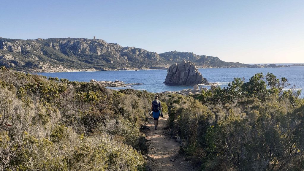
From in front of the HOTEL CAMPOMORO, facing the sea, turn left towards the tower, after leaving the village, you enter a private residential area of villas, climb up this road until the road heads left and you see the CONSERVATOIRE DE LITTORAL sign at the base of the tower hill. Turn right here, and immediately after the large map, turn left downhill.
(PLEASE NOTE you can detour to the tower by following the signs to the right, cost €2.50pp time 20 mins – once visited, take the path left out of the tower to CALA GENOVESE and turn left on reaching the sea, once you get to the grassy area you are at I POZZI). If you don’t want to visit the Genoese tower (the largest on the island) the path drops and opens up onto a grassy area. I POZZI by the sea with good views of the tower above.
YOU HAVE TWO OPTIONS HERE, COASTAL OR ON RIDGE
ON THE RIDGE OPTION
- A. I Pozzi (to Canussedu stream) 1h10 /2.5km
From the start of the grassy area, facing the sea, turn sharp left straight away, there are low metal posts. You are walking into the maquis, then climbing, following a ridge path, with views out over the Valinco Gulf. After about 20 mins you arrive at a stone threshing circle, the circular BOUCLE I POZZI (low post) walk leads off to the right here, you head straight on at this fork which is behind the threshing circle signposted CONCA, SENETOSA, TIZZA PAR LA CRETE, continuing on an easy climbing path along the hill, before dropping down behind the creek at CANUSSEDU (low post signs for BOUCLE de CANUSSEDU).
- A. Canussedu (to Cala d’Aguglia) 1h15 / 4.5km
Ignore the turn to the right, which passes the pond (full of turtles if you want a peak). You are following the path to PUNTA DI MANNA MULINA which rises again to the ridge and the summit before dropping down again gently. The path follows parallel to the coast before turning away, to your left downhill into a valley the VANGONE D’AUCIA before it reaches the back of the inlet at CALA D’AGUGLIA. You may see a low post for TIZZA CALA DI CONCA and SENETOSA but the junction is hidden. If the path opens out to a wide grassy area you may have gone on too far so retrace your steps a little to find the path.
- A. Cala d’Aguglia (to Cala d’Arana) 0h30 / 1km
From the hidden junction, you are bearing left, off of the path that is marked BOUCLE DE MANNA MULINA. The path immediately crosses a gully stream bed and begins climbing again through low woodland then more open maquis up to a pass between the two hills, before dropping down gently again to a walled area that you cross and see a worn waymark, before again approaching the sea at a succession of white sandy coves. Follow on to CALA D’ARANA at N° 5.
ON THE COAST
- I Pozzi (to Canussedu) 1h00 /2.5km
From the far end of the grassy area, facing the sea, turn left into the maquis, near the rocky beach, following the coastal path (some posts), the path more or less follows the coast in and out of woodland and maquis with views out over the VALINCO Golf. After crossing a stream, a loop walk I POZZI leads off to the left (you may see a squat post), you head right at the fork and you will soon see a cave to your left. As the path gets closer to the sea, chains show your way around a rocky headland before climbing under a huge boulder, and into a Tafoni sculptured landscape the other side. The path is gentle and meanders through this maquis and follows onto the next stretch of coast which is soft underfoot. The path leads between rocky outcrops, and through stone walls, before arriving at a flat area of land, and a wall that you cross to reach the creek at CANUSSEDU.
- Canussedu (to Cala d’Aguglia) 1h00 / 4km
From the beach at CANUSSEDU, the path climbs on steps above the cove on the right hand side. Occasionally you will see weather battered short posts for CALA DI CONCA or SENETOSA. The path follows the coast on the flat before turning abruptly left uphill a little, as it reaches the inlet at CALA D’AGUGLIA.
- Cala d’Aguglia (to Cala d’Arana) 0h45 / 2km
From the beach take the rising path to the left that climbs above the valley floor, after a few minutes you drop down again and reach an open area and then a junction, you are bearing right, not the path that leaves to the left marked BOUCLE DE MANNA MULINA on a low post. The path crosses the stream bed and begins climbing again through low woodland then more open maquis up to a pass between the two hills, before dropping down gently again to a walled area that you cross and see a worn waymark post, before again approaching the sea at a succession of white sandy coves.

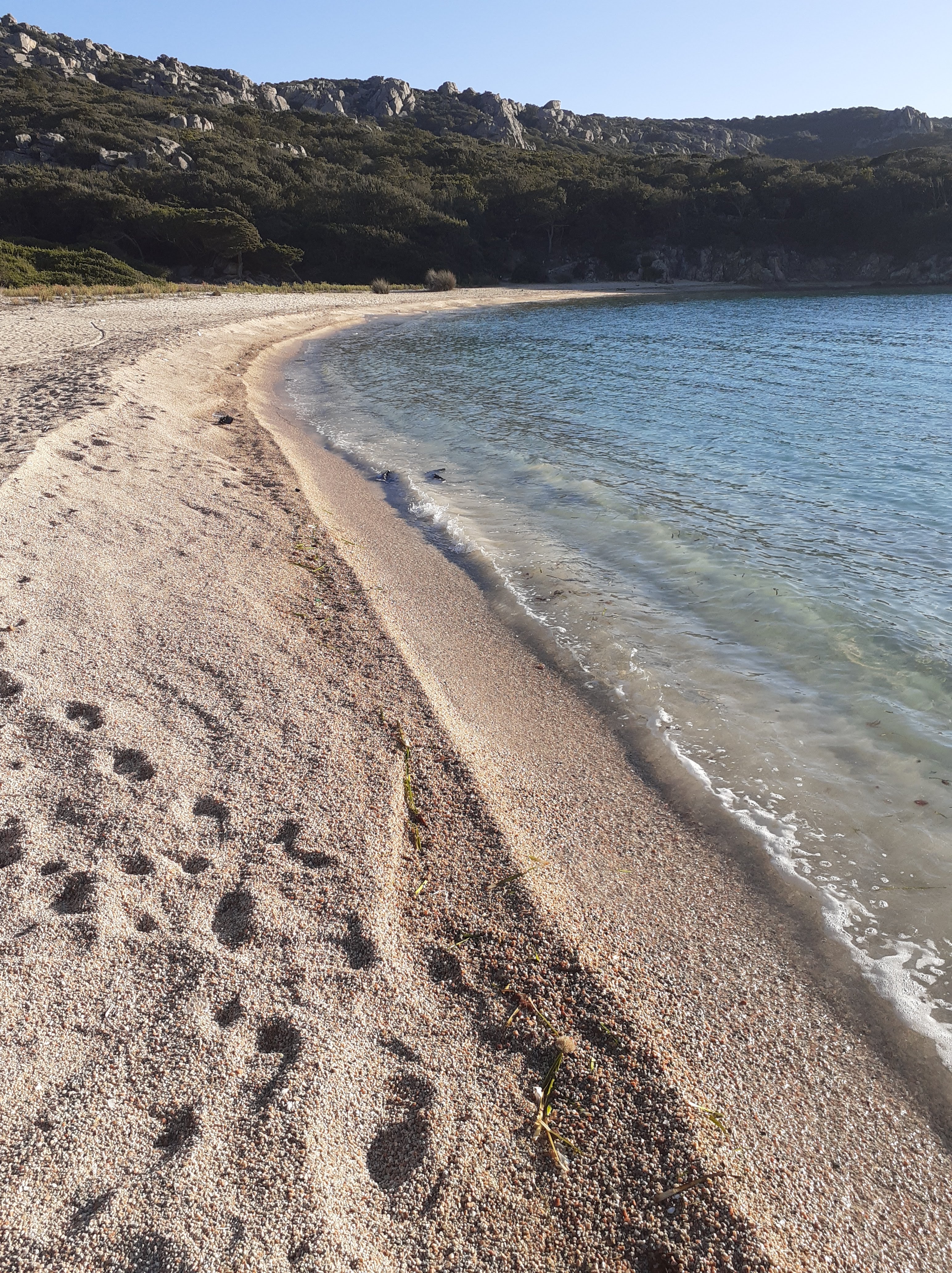
- Cala d’Arana (to Cala di Conca) 0h45 / 2km
From here you skirt around the 3 coves on this unspoilt section of coast before climbing across another rocky headland. You then again rejoin the coast as the land flattens and see a large granite pillar in the sea, following the path for another 20 minutes you arrive at CALA DI CONCA, dropping down to the back of the beach.
- Cala di Conca (to Senetosa) 1h15 / 3km
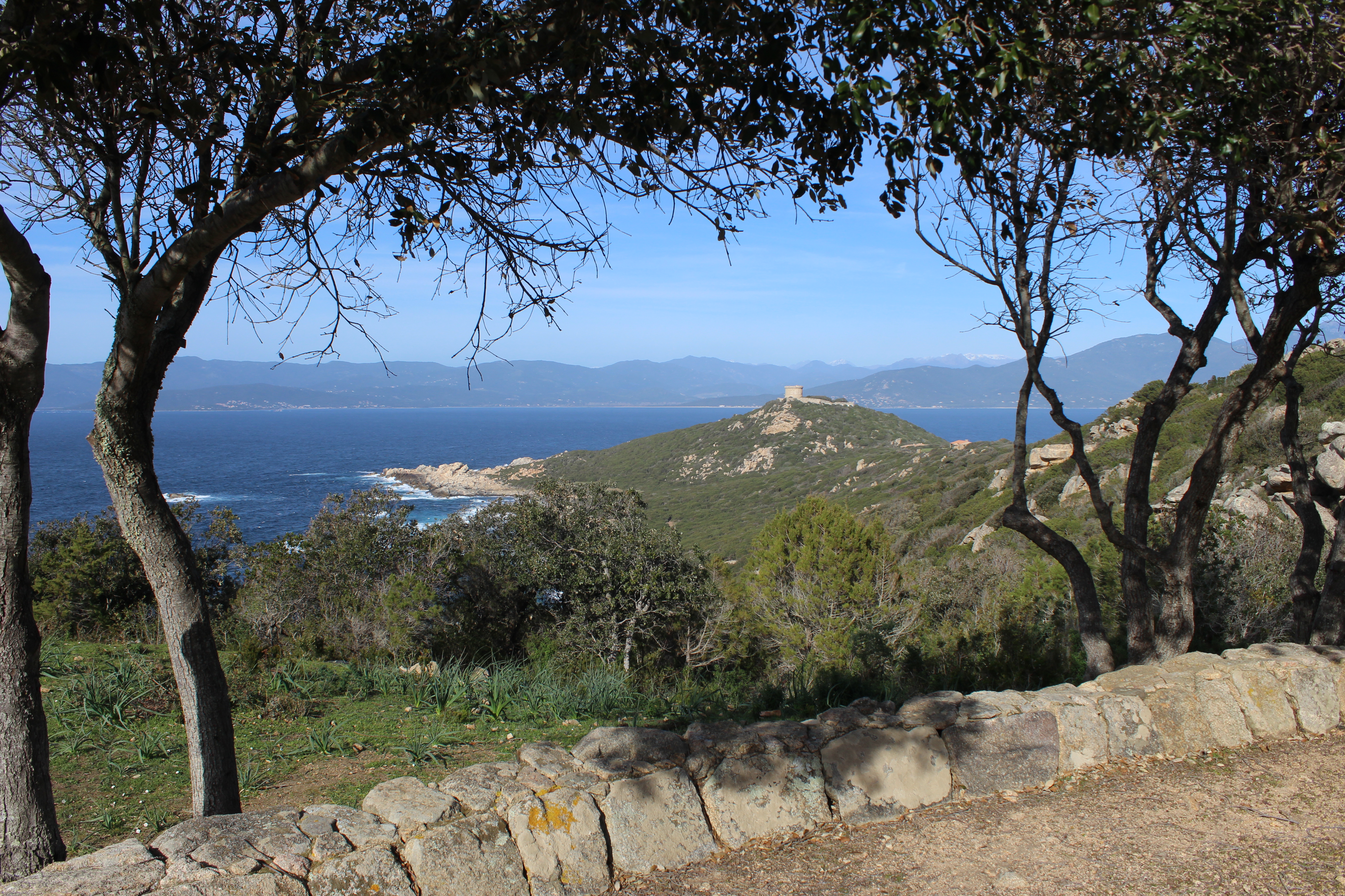
From the other side of the beach the path climbs to the right along the coast, past a ruin. The path follows the coast through taffoni and when nearing the CAPU DI SENETOSA you see fields of immortelle. You have lost sight of the lighthouse, but soon on contourning the headland you see it again up to the left. KEEP TO THE MAIN PATH, and where a fence blocks the track, near the old vegetable garden, head up into a jumble of rocks climbing steeply at the end to find the light house to your right.
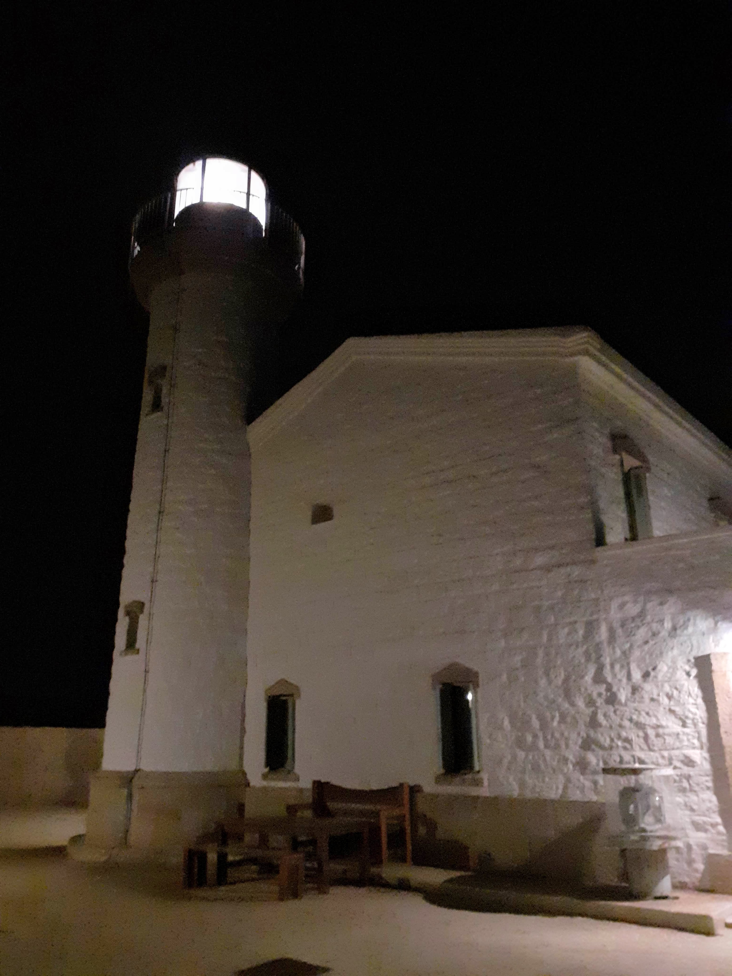
Senetosa Lighthouse
Situated on one of Corsica’s most remote and wild coastlines Senetosa is an isolated lighthouse, and a real paradise. “The most isolated lighthouse of Southern Corsica”, thankfully any road projects envisaged in the late twentieth century, failed, leaving SENETOSA only accessible on foot along well worn tracks. The Lighthouse was transformed into a Refuge in 2016 by the Conservatoire du Littoral who upkeep this unique building.
Constructed in 1890, until the 1950s, the two lighthouse keepers lived at the lighthouse with their families, far from everything, they had little contact with the outside world. Water had to be sourced at nearby Cala di Conca, with mules, and the families grew vegetables in the square walled garden below the lighthouse, and spent any spare time hunting and fishing for extra supplies. From the mid 1950s, the keepers lived alone, their families housed in BONIFACIO, PORTO VECCHIO or AJACCIO.
In 1988 the Senetosa lighthouse was automated but the keepers remained on site for another 20 years, until 2008. Today the 2500 hectares that surround the lighthouse are a protected reserve guarded by the Conservatoire du Littoral and their guardians. The light shines 22km out to sea and it is magical to pass the night here lulled to sleep with the sweeping light.
Refuge Charter
I am only passing this place, I leave with all my rubbish – leaving the site clean, as this place is protected, I respect it, I limit my use of electricity, I am careful with water and I use the ecological dry toilets, I do not disturb other guests and I do not make fire so that everyone can enjoy this wonderful site.


Important information about the Refuge du Phare de Senetosa
- For the shower you will need tokens (€3 for two tokens), hot water is for a fixed time. Take a lightweight towel with you as none provided.
- You will need to buy WATER for the walk or bring it in with you – for each day a good 2 to 3 litres per person. THERE IS NO WATER EN ROUTE. Bottled water costs €3.50 for 1.5l. The water at the refuge is not suitable for drinking as is very chlorinated.
- DRINKS can be purchased from the refuge. A can of coke, liptonic, orangina etc will cost €3, a pitcher of 50cl of local wine around €6.50, a Pietra beer €5. A small coffee costs €1.50.
- BREAKFASTS provided consist of Toasts / Biscottes & Butter, Canestrelli biscuits, Jam, Coffee, Tea or Chocolate, Fruit juice. If you need a more copious breakfast, please plan ahead and carry in with you.
- ORGANIC RUBBISH There are compost bins for food remains (eg vegetables, fruit, bread, pasta, rice & grains) onsite.
- COOKING FACILITES & DINING ROOM There is a Barbecue on site, a fully equipped kitchen with plates, glasses and cutlery.
Senetosa to Tizzano
The most remote lighthouse on the island and another Genoese tower, with some of the most magical coastline.
9km to BARCAGGHJU / 12km to TIZZANO, 1h45/ 3h00, +/-125 m, LOW POSTS YELLOW
FOOD: SARTENE, TIZZANO
WATER: bottled water at SENETOSA
- Phare de Senetosa (to Tour de Senetosa) 0h20 each way
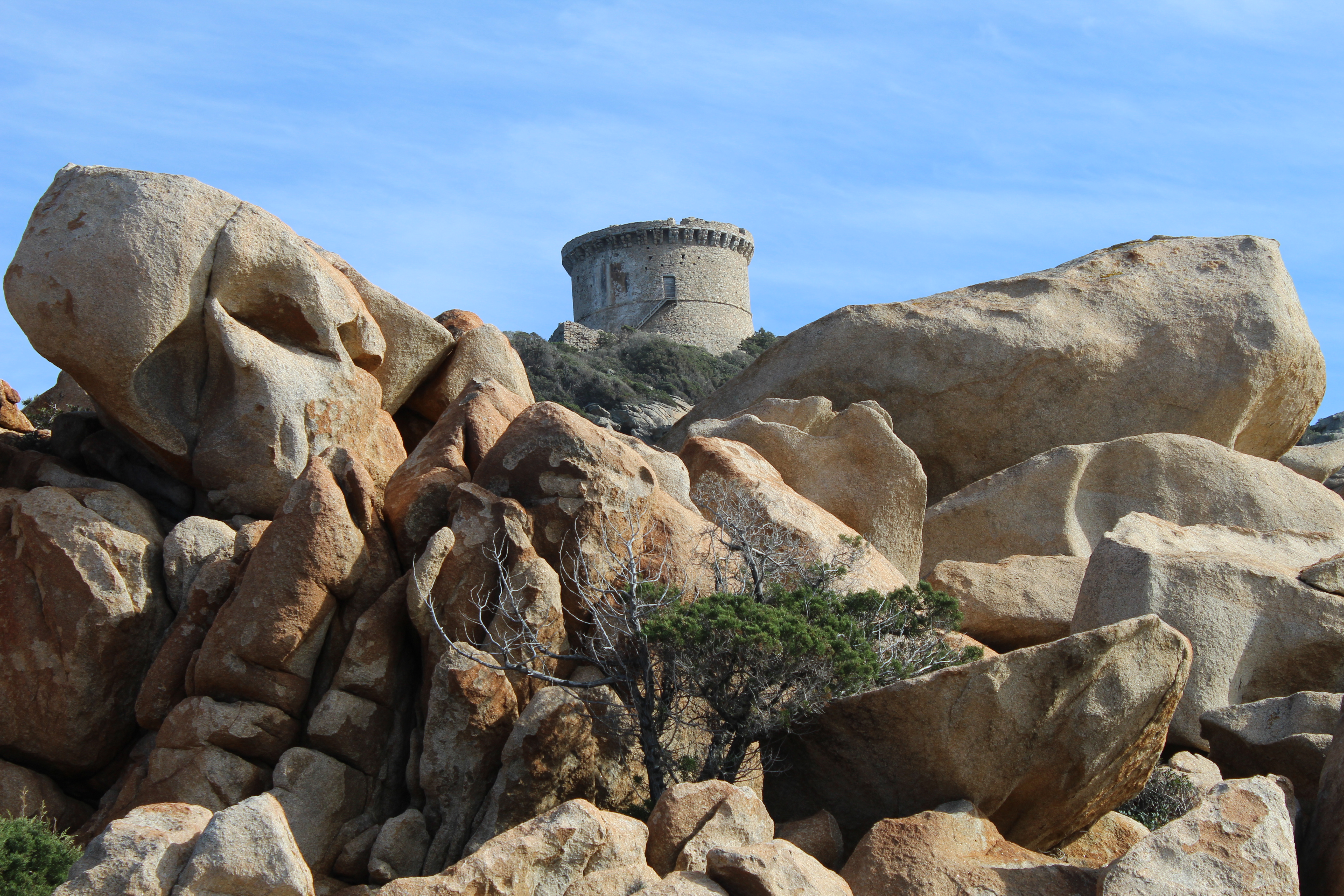
From the front of the refuge, take the climbing path straight ahead. The path soon splits, signposted TOUR DE SENETOSA, and you continue left the climb, zig zagging up to the tower. On reaching a wooded area, the tower is on the crest to the left, a scramble up the rocks. The TOUR DE SENETOSA was built late in the seventeenth century to protect the CAP DE SENETOSA: it was part of the “difficult” towers whose construction was delayed. Thanks to these watchtowers, the inhabitants could scan the sea horizon and sound the alarm in case of approaching pirates. The Genoese towers are the physical witnesses of the defensive organization and the protection of the Corsican peoples against the barbarian invasions. Nowadays, their silhouettes have become an iconic symbol of Corsican shores. To preserve this exceptional heritage and open it to the public, the Conservatoire du littoral has completely restored the tower. The TOUR DE SENETOSA is circular in plan, rendered and surrounded by defensive chutes spaced at a regular intervals. Like all Genoese towers in Corsica, it consists of two levels and a terrace: the first level contains a tank collecting rainwater and the second level the living room of the guards. An internal staircase leads to the observation deck surrounded by machicolation. The architecture of the towers is at the same time minimalist (answering a particular need and built quickly without superfluous) and very representative of the defensive Genoese military architecture of the 16th and 17th centuries.

- Senetosa (to Cala di Tivella) 0h25 /1.5km
From the junction you head left. The path drops through boulders into the maquis towards the beach at TIVELLA. Cala di Tivella is probably the best beach on this walk, made of coarse sand with a large rock in the centre of the bay, the water is clear and a haven for fish.
- Cala di Tivella (to Cala Longa)0h10 / 0.5km
Cross the beach to the far side, the path leads off from the back of the beach, through the maquis, you pass wind sculptured rocks and soon you are skirting the next inlet CALA LONGA
- Cala Longa (to Cala di Capiciollu) 0h30 /1km
Cross the beach near the water line. The path leads up a gulley opposite. The path climbs into the low maquis covered valley, up to a rocky and open ridge through a very different landscape of boulders, the path then weaves down through the maquis into another valley and then under trees down to the cove at CALA DI CAPICCIOLLU.
- Cala di Capicciollu (to Cala di Barcaghju ) 0h40 / 2km
From the back of the beach, the path heads around behind a lone tree. You will see occasional way marks and cairns as you head over boulders, soon arriving at a yellow signpost for the PHARE DE SENETOSA and TIZZA. From here care, do not take the large track in front of you far. At a clear area around 20m onto the track, head towards the right, through boulders in the direction of the sea, keep as close to the coast as possible, you should see some wooden posts with yellow way marks that have recently been installed. Weaving in and out of the low maquis the path then crosses the beach, the coast opens up onto large open expanses of rock scattered with magnificent Taffoni, after some switching back and forth across the headland, keep on this easy to follow path, close to the sea, you will discover some coves around the Murta Spana, before the path leaves the coast at right angles where you see another yellow signpost indicating TIZZA at a junction with a dirt track. Turn right along the track towards TIZZANO. (There is a paillote restaurant on the beach at BARCAGHJU after 200m).
- Cala di Barcaghju (to Tizzano) 1h00 / 3km
The last stretch is along this dirt track all the way to TIZZANO. Follow at all times the track, do not until you reach the village at some restaurants and a small store. Continue along the road for the heart of the village.
- Tizzano


