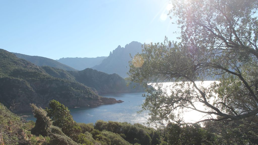
This is quite simply a fabulous, relatively secret (ssshhh) coastal walk along the GOLFE DE PORTO. You have to keep your eyes on the terrain, which is sometimes steep sea cliffs – not ideal for those with vertigo, but the views are sublime out over the Golfe.

- Bocca a Crocce (to U Pratu) 0h35
From BOCCA A CROCCE, take the shortcut down into the village of OSANI. Standing with your back to the BOCCA A CROCCE at the end of the car park and on the dirt track, you see two new water tanks ahead of you (approx 40m), before these and just a few steps from the car park, a path drops down to the left under branches (parallel to the road for around 10m), before dropping down towards another water tank marked RVOIR, and the village of OSANI.
From here, walk downhill to the centre of the village, taking the D424 towards the beach and the last house of the village (cream with a turret). Shortly after, you will see a garage and a trail rising on the right by a cross. Climb here (signposted SENINU, E GRADELLE, CASPIU).

NB. The path along the coast is at times exposed and you should not proceed in bad weather, we advise you not to go past a certain point after the FONTAINE DE MISERINU.
The trail is way-marked in yellow dashes of paint to both U GROTTU (on MT SENINU) and GRADELLE beach. Climbing at first, before levelling, after just 500m the path opens out onto rolling farmland, take time to look over the valley to your left you can see the low building U PRATU which you will be passing behind later.
Here the track is wide and open before narrowing again to a path as it climbs away from the farm track, and after a further 400m (20 mins from the village) the path opens up to a wide view of the sea in front of you. You are not heading onto the headland of SENINO. You will see a low stone with a faded yellow waymark also in front of you, and a post marked GROTTE / GRADELLE on your right (slightly behind you and easy to miss). Here you turn left on a gently falling path, to meet almost immediately a stone wall, at which you turn right towards the sea and you will shortly see a wooden sign for E GRADELLE in a clearing. From here to the summit CAPU FINOSU the sea is on your right, and the stone boundary wall for U PRATU (broken in places) on your left.
You pass behind the messy stone building marked U PRATU on the maps that you saw earlier. There is a lot of building rubble around, old cars and other debris.

- U Pratu (to Gradelle beach) 1h30
Follow carefully the yellow waymarks that lead roughly parallel to the back of the house across the debris. The terrain on your right starts to fall steeply away to the sea below with spectacular views (you will suddenly see an old metal bed that has been placed to take in the view – you pass behind this). Approach the wall over to your left, following parallel to it and you will soon again pick up the yellow waymarks that now head steeply up to CAPU FINOSU.
On reaching the summit, you follow the ridge line, crossing CAPU FINOSU, continue onto a high point at altitude 263m (after 1 hour). Here you reach a tricky downhill section, CARE the terrain is a little rough, eroded and steep here and can be very loose underfoot.
The path remains on the ridge all the way, dropping steeply a couple more times. Follow the ridge until your veer left downhill through the trees to the road. Turn right and walk the short distance to the beach.
- Gradelle plage (to Baie de Caspiu) 0h45
Moving away from the ruins, cross the beach at GRADELLE, and from the far corner of the cove, a path leads uphill and follows the cliffs along to the next bay, on the crest you pass a crop threshing circle. Ignore any intersections and be attentive to way marks. After a good 20 minutes you will arrive at CASPIU beach.
- Baie de Caspiu (to Fne de Miserinu) 1h00
The trail from CASPIU follows the steep and sometimes vertiginous sea cliffs which in places are exposed. YOU DO NOT FOLLOW THE YELLOW WAYMARKS ALL THE WAY. Cross the beach and head up the slope the other side. The path climbs steeply, and you reach a junction that carries on up the ridgeline to the BERGERIE on the CAPU RAZZOZU just on the road out of PARTINELLO. You can turn right here and follow along the road for 2km to BOCCA PAGLIAGHIA.
If you continue, the first section to the FNE DE MISERINU is easy enough underfoot, although it is steep in places and you are walking on a ledged balcony path. The spring FNE de MISERINU is at the place indicated on the map but does not have running water.
From the spring you pull steeply up-hill, as the path levels out at 100m altitude, and before dropping again below two trees, there is a slip route off the path up to the left that is marked by cairns and red waymarks. I ADVISE YOU NOT TO GO PAST THIS POINT ON THE COASTAL PATH, the path, although waymarked with some work having been done on it is dangerous and on steep sea cliffs.
- Hillock above Fne de Miserinu /slip route to the D81 (to Bocca Paliaghia) 0h45
As the path levels at 100m altitude on a hillock, turn left quite steeply uphill following occasional red painted waymarks and stone cairns. You are walking up to the road, following a hunters path, always heading uphill. Ater 300m and 75m ascent you arrive at the road (this could take 20 mins). Turn right in the direction of PORTO, and follow the D81 road for 1.5 km / 20mins through the Calanches.
After 1.5km on the road, you turn right into a concrete driveway (at this point the road heads inland away from the coast, there is a layby, bins and a telegraph pole). At the end of this driveway, there are the brown gates to two houses, bear right, taking the small path that runs alongside the garden fence at BOCCA PAGLIAGHIA.
- Bocca Paliaghia (to Bussaghia) 0h40
The path continues gently downhill along the ridge, heading out towards the rocky point of the PUNTA BIANCA headland before heading to the left, zigg zagging down with stunning views to-wards the golfe de Porto and the beach at BUSSAGHIA. Following the yellow waymarks, you will arrive at BUSSAGHIA beach at the mouth of the river VETRICELLA. You may have to wade across.


