Saint Florent to Lodu and Saleccia beaches, coastal walking at its finest.
The Desert des Agriates stretches from Saint Florent in the North, to Ostriconi. The area is arid, with low maquis, that meets the coast at some of the most paradisiac beaches on the island. You can catch a boat (MAY TO SEPT) to the beach at LODU, making it just a one way walk.
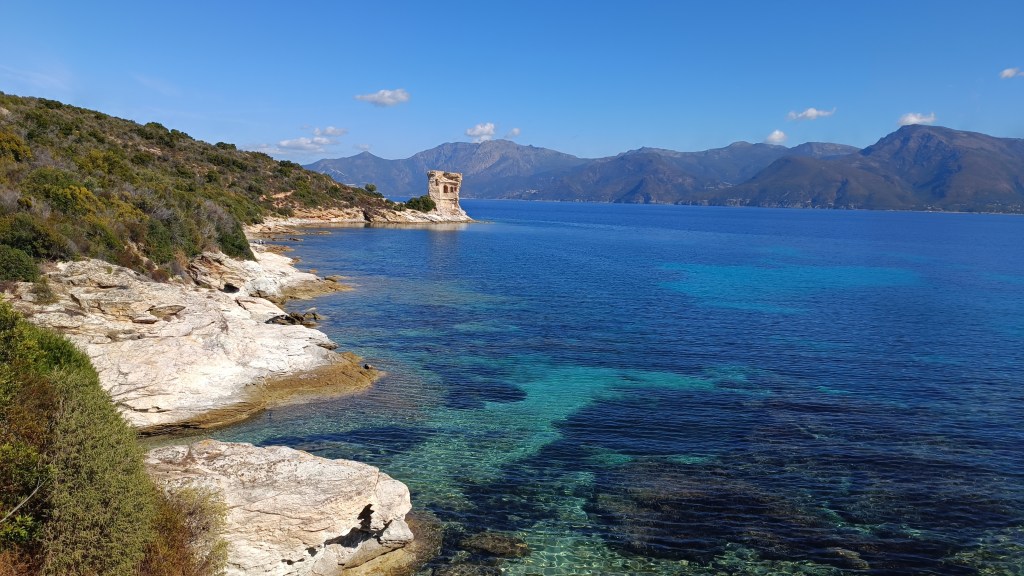
« Another great coastal walk, take care in hot weather as there is little shade. The tower at Mortella was partially destroyed by a bombardement by the British fleet. So impressed by the structure, Nelson suggested the building of MORTELLLO towers on the south coast of England.»
This walk can also be a 4h30 there and back to beach at LODU. For this you need to park at the CONSERVATOIRE DU LITTORAL parking area and follow the instructions at the end*.
13km / 4h30 / +100m / -100m / Some low posts, YELLOW

Food supplies: SAINT FORENT, beach restaurant near jetty at LODU.
Please Note: Take plenty of water with you in hot weather and DO NOT ATTEMPT TO GO OFF TRAIL. We found a walker scratched and in a stage of dehydration on arrival at Fiume Santu who had tried to go inland to cross the river. You may need to wade so keep belongings high and be brave !
From SAINT FLORENT you need to get the POPEYE boat to PLAGE DE LODU. This leaves from the harbour in town, cross the bridge towards the carpark just before the SPAR supermarket, and follow the red signs to the left that leads to the jetty. The boat trip takes approx 20 mins before arriving at the beach at LODU.
- Plage de Lodu (to Punta Mortella) 1h00 /3km
From the boat jetty, head off left, around the coast to drop down onto the beach at LODU. Cross the beach, you are heading straight across to join the path on the coast. After 500m on this path, you cross PLAGE DU PETIT LODU, which you again cross to rejoin the path on the opposite side of the beach. The path sticks near to the coast to the next headland PUNTA CAVALLATA, then climbs towards the Semaphore on the PUNTA MORTELLA. The trail heads towards the MORTELLO TOWER and the old lighthouse at PUNTA MORTELLA (off to the left on arriving near the coast).
- Punta Mortella (to Fiume Santu) 0h40 / 2km
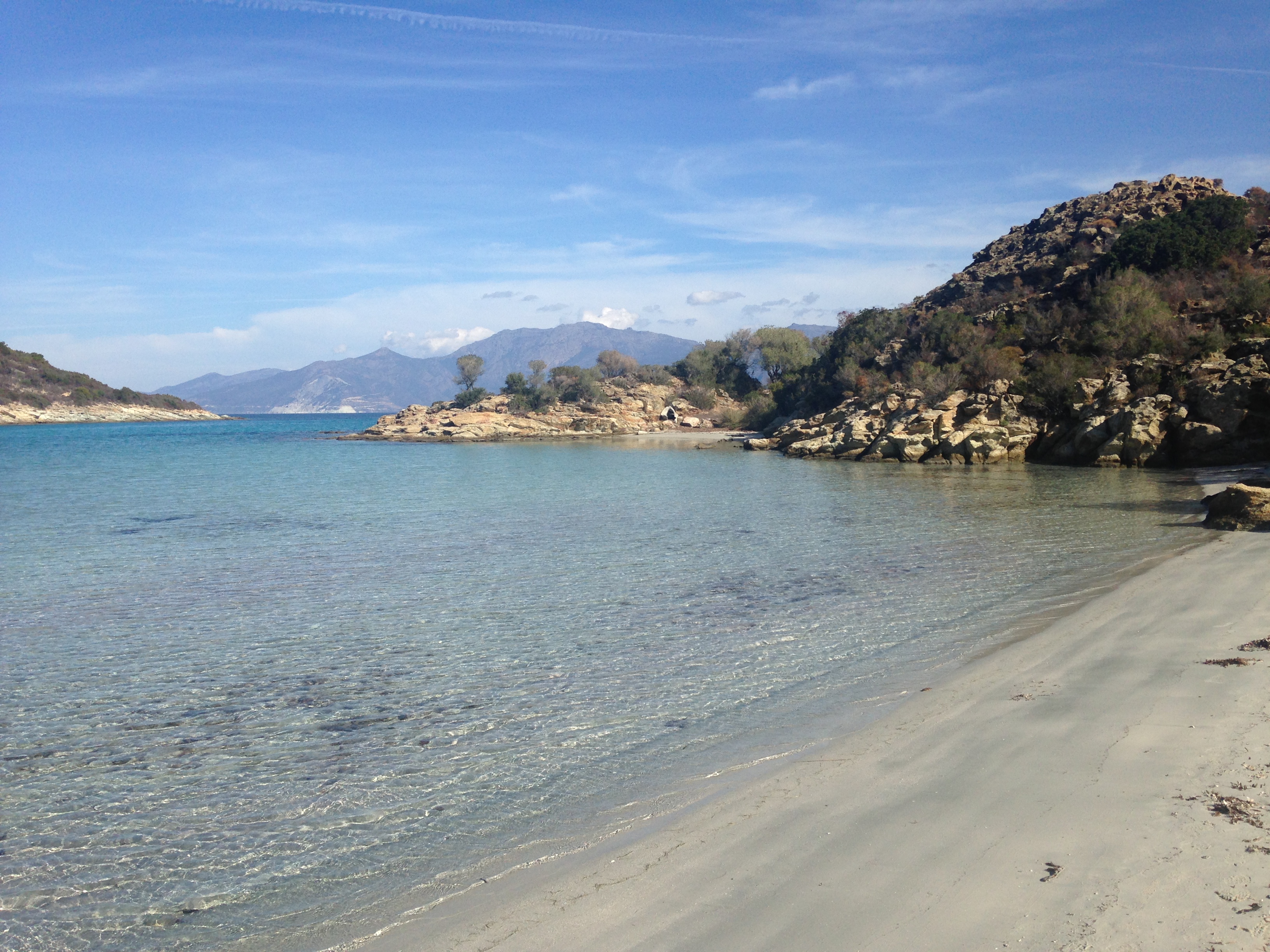
The path continues along the coast from the tower, and after a further 30 minutes you arrive at the Fiumu Santu, another fine cove, where you may need to take off your shoes and wade through the water. At the rocks at FIUME SANTU you need to cross the creek. Don’t necessarily take the shortest route, it may be deeper inland than in the bay as the beach reappears after times of drought. The water should not be higher than your thighs. The best passage is in an “L” from the rocky outcrop / waymark.
- Fiume Santu (to Bugghiu) 0h20 / 1km
On the sand the other side of the beach the path climbs around the coast to Buggiu beach, follow the way-marks sticking more or less to the coast in low maquis before dropping down through the rocks to the beach.


- Bugghiu (to Fornali) 1h00 / 3km
Cross the beach again and the path is easy to find and leads below the old fortress and above the many creeks. You turn a distinct right before reaching an area of private villages, with a gate. Be careful to close the gate, you will reach a second gate after around 20 minutes. After the last gate you are heading between the grounds of the Domaine de Fonavert and the sea.
- Fornali (to Saint Florent) 1h30 / 4km
From the car park area climb to join the dirt track and turn left and walk back along this towards the beach at SAINT FLORENT. From the LA ROYA beach Saint Florent, head onto the main road, cross the iron bridge to the left and heading back to town.
THERE AND BACK WALK OUT OF SEASON
For this walk you will need to park up at the parking area near the Anse de Fornali.
Due to private properies hugging the coast before the Anse de Fornali, the walk really starts after the LA ROYA beach near Saint Florent, taking the D81 road south towards Ile Rousse and Calvi. On crossing the iron bridge, turn immediately right towards the beach and campsites at LA ROYA, continue all the way along this road, past the beaches, the road turns sharp inland at a final car parking area by the beach, before heading right up an un-tarmacced road between private properties, drive along here for around 10 minutes, the track becomes more dusty and you should see some cars parked in a rough area off to the right – a bumpy ride but worth it to avoid the walk on foot.
- Anse de Fornali (to Buggiu) 1h00
There is a parking area on the right at Anse de Fornali. Your walk sarts here. Heading towards the sea, walk down through the car park, (note the sign indicating fire risk and don’t proceed if the situation is critical)
The path is easy to find and leads off to the left before reaching the inlet, falling at first over a stream before climbing slightly between the grounds of the Domaine de Fonavert and the sea. The path is indicated Chemin du Littoral and hugs the coast.
After a few minutes, you pass through a gate, be careful to close it and stay on the path as this is private property of villas, reaching another gate after 20 minutes. The coast has many small creeks before you bare distinctly left below a fortress looking building prior to reaching the beach at the mouth of the Buggiu after an hour.
- Buggiu (to Fiume Santu) 0h20
You could stop here, and retrace your steps, or continue onto the beach at the mouth of the Santu and then the Mortello tower.
The path climbs into the rocks from the end of Buggiu beach, follow the waymarks sticking more or less to the coast in low maquis. After a further 20 minutes you arrive at the Fiumu Santu, another area of sand, where you may need to take off your shoes and wade through the water. DON’T NECESSARILY TAKE THE SHORTEST ROUTE, you head straight out then left, it may be deeper inland than in the bay as the beach reappears after times of drought.
- Fiume Santu (to Punta Mortella) 0h40
The path climbs steeply from the other bank into the rocks (you’ll see a low post and you will see waymarks) then descends behing the next small cove, it then again continues along the coast, following the markers, to the Mortello Tower just over 30 minutes after leaving the inlet.
Retrace your steps back to the car. Round trip back to parking area around 4h00.


