The SCALA SANTA RÉGINA is a trail of great historical importance, as it was the path used by shepherds leading their herds in and out of the NIOLU valley. It winds incredibly through a decor of granite cliffs, along a superb balcony path to the ERCO Genoese bridge. A walk through old chestnut groves leads to the path descending to CALACUCCIA village.
11km / 5h00 / +850m / -550m / ORANGE & VIOLET
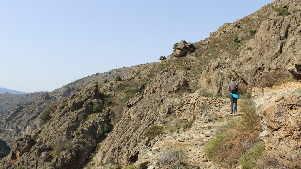
A great walk of historical importance, this walk explores the true heart of Corsica, the Niolu. You are in high mountains, a really mineral environment. Stop at Ercu bridge for a picnic.

- Scala di Santa Régina spring (to Corscia) 2h00 / 5.5km
You start at the spring, fill your water bottles if you haven’t already done so. Take the rising path to the left of the spring, waymarked ORANGE VIOLET. The path leads up through the rocks and soon becomes a cobbled mule path that runs parallel to the D84, SCALA DI SANTA REGINA road. The path follows the mountainside, passing a small waterfall FALCUNAGHJA, clinging to the side of the valley, then after 2km, you will arrive at a river and bridge at la RUDA, indicated with a red star on your map, it is a good place for a first break.
The path goes uphill in a series of short sharp switchbacks, then stretches out offering good open views towards CALACUCCIA, where there is a lake and a dam. As you approach the village of CORSCIA, you will notice a solitary chapel in the distance on a hilltop, SAN PANCRAZU.
At 4.5km you will come to a point where there are two signs that give options on how to arrive in the village. One sign is marked CORSCIA HAUT DU VILLAGE, the other CORSCIA LIASON DIRECT. Take CORSCIA LIASON DIRECT waymarked ORANGE VIOLET. Be attentive here, five minutes later, another sign directs you slightly uphill towards the village, between stone walls. Walk to an isolated white house with red shutters, at the entrance to this you will see a road, continue left along the road for 200m.
Just before the road heads downhill, turn right uphill on a steep climbing path through a messy area, reach a concrete lane and walk uphill to the main village road. At the road, you will see, on your right, a village building the CASA COMMUNE/MAIRIE. Turn left along the road.


- Corscia (to the Pont d’Erco bridge) 1h00 / 2.5km
Walk down the D618 road to the bend, you will see a number of signs. PONT D’ERCU, LOZZI. Leave the road here and climb to the right, follow the initially paved path that climbs uphill between walls and then fields, waymarked ORANGE VIOLET, passing twin crosses at CROIX DE POGGIE after 15 minutes. The path then drops down, is easy underfoot, between path and tracks, all the way to the PONT D’ERCO bridge.
- Pont d’Erco bridge (to Chestnut Grove) 1h00 / 1.5km
The PONT D’ERCO bridge, it is a very picturesque spot and it’s worth stopping. Cross the bridge, follow the path, initially left, then right uphill, ignore any slip paths and following attentively the waymarks. You walk up through an area of old bare chestnut trees passing a spring, before climbing again.
After a steady climb, you arrive at a junction with a wide path signposted CAMPING to your right, turn left towards LOZZI, the wider path continues to climb passing a fenced tidy chestnut wood, and flattens at the entrance to this enclosure at a track. Continue on the track. You see a number of vintage vans in a field to your left. Continue along the track for just over 100m passing a field with a small cow shed. As the track opens up, leaving the chestnut woods behind, you need to head off the track on a path downhill to the left at an open grassy area.
- Chestnut grove (to Calacuccia) 0h45 / 1.5km
You may see an old wooden sign in the brambles CALACUCCIA 40 mins. Continue left (there may be an initial cattle “gate” made from palettes, bedsteads, car bodywork etc – if so close it). Continue along the path between dry stone walls gently downhill. You reach another “gate” at a lone tree after around 200m, go through, closing again, the path drops down steeply after this, levelling out again before heading left. Ignore any paths that cross field to field, keep to the main path between the drystone walls. After around 1km the path opens out at an area with a large concrete water tank. Continue straight ahead, along another path, you reach a metal gate, pass through this, continue straight ahead, and arrive at a junction. Here you can turn right, towards a yellow house, pass the garden and the house and drop down to the road. Turn left, then switch back right after 20m, dropping down a large cobbled lane to the chapel opposite the MAIRIE in CALACUCCIA.


