Fabulous coastal walking, there are a number of loop walks that take in this unspoilt stretch of coastline in Corsica, south of the largest Genoese tower on the island at Campomoro.
“A firm favourite. The walk is relatively easy going but don’t underestimate it, there is no water en-route and it can be a killer in the heat. The road to Campomoro is long and winding and parking in Campomoro can be a nightmare ! Arrive early in high season.”
5km, 1h45 (I POZZI) / 7km, 2h45 (CANUSSEDU) / & 14km, 6h00 (AGULIA – MANNA MULINA), +/-321m, LOW POSTS
FOOD: CAMPOMORO WATER: No reliable springs

- Hotel Campomoro (to I Pozzi) 0h20 / 0.5km
From in front of the HOTEL CAMPOMORO, facing the sea, turn left towards the tower, after leaving the village, you enter a private residential area of villas, climb up this road until the road heads left and you see the CONSERVATOIRE DE LITTORAL sign at the base of the tower hill. Turn right here, and you will see a large map.
YOU HAVE OPTIONS HERE
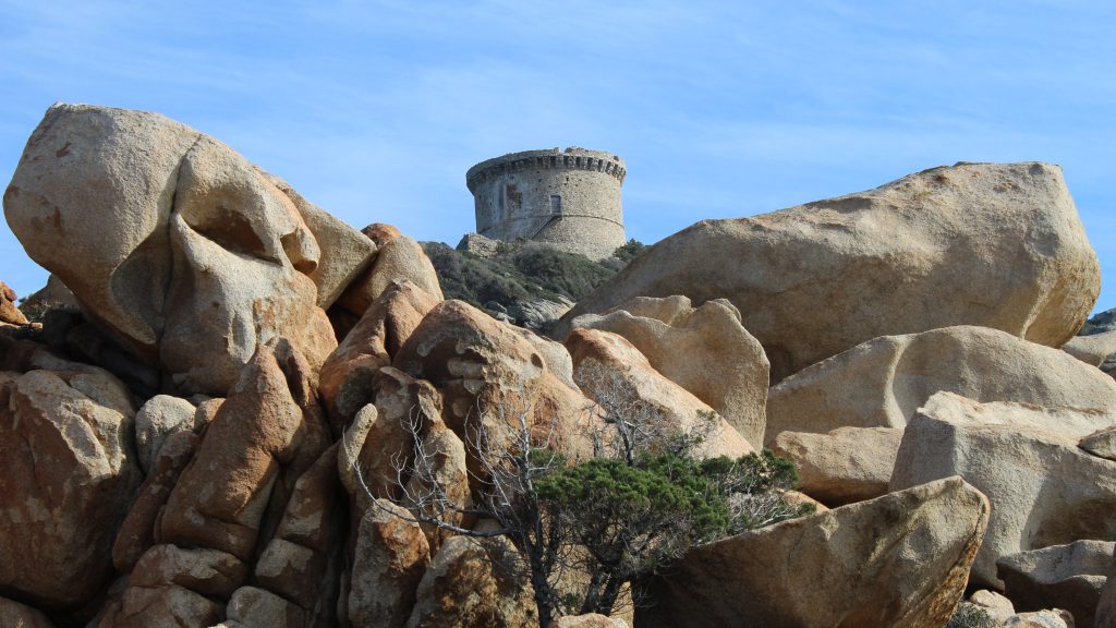
OPTION 1 – TOWER & CALA GENOVESE
From the map, detour to the tower by following the signs to the right. After 100m the path heads up to your left and starts the zig-zagging climb towards the TOUR DE CAMPOMORO, the largest on the island. After about 500m you arrive at the access to the citadel. The citadel is open at all times of year, but from APR-OCT, the cost for access to this and the tower is €2.50pp – once you have visited, take the path left out of the tower to CALA GENOVESE. For a long walk (see options below), turn left on reaching the sea, through a landscape of boulders, once you get to the triangular grassy area you are at I POZZI (see below).
To arrive back at the large map at the foot of the tower, you can head right, the path hugs the coast, gently climbing towards the end, meandering back to the concrete road.

OPTION 2 – ALONG THE RIDGE TO CALA AGULIA
- I Pozzi (to Canussedu stream) 1h10 /2.5km
From the large map, turn left downhill. The path drops and opens up onto a grassy area. I POZZI by the sea with good views of the tower above. From the start of the grassy area, facing the sea, turn sharp left straight away, there are low metal posts. You are walking into the maquis under low trees, then climbing, following a ridge path, with views out over the Valinco Gulf. After about 20 mins you arrive at a stone threshing circle.
For the first shorter walk – the circular BOUCLE I POZZI walk leads off downhill under trees to the right here. Passing a spring after a few metres.
Behind the threshing circle take the marginally left hand path signposted CONCA, SENETOSA, TIZZA PAR LA CRETE, continuing on an easy climbing path along the hill, the path begins dropping down behind the creek at CANUSSEDU. You again reach a junction on paths.
For the second shorter walk – the circular BOUCLE de CANUSSEDU walk leads off to the right here. The path runs under thick woodland along side a stream and opens up after a few minutes as it passes the pond (full of turtles and frogs) the walk is then open and reaches a wall alongside the creek at CANUSSEDU.
- Canussedu (to Cala d’Agulia) 1h35 / 4.5km
Ignore the turn to the right. You are following the path straight ahead to PUNTA DI MANNA MULINA. After 100m you reach a junction that cuts across the path (a bridleway) and a gap in the wall. Pass through this gap continuing on the path and then enter a wooded copse and cross the stream. The path turns right and then starts to rise again, initially in zig zags quite steeply. Views open up to the coast to the right. The path continues to rise up up the ridge with numerous viewpoints. There are sections in and out of high maquis. After around 35mins (1.5km), as the path flattens, you arrive into woodland, with boulders to your left. You are nearly at the summit at MANNA MULINA, take the path to your left indicating the viewpoint and climb up the rocks for a panoramic view (there is an easy access from behind).


From here the path flattens, opens and meanders along the saddle with views towards SENETOSA and along the coast. The path follows parallel to the coast before turning away, to the left, downhill alongside a wall, into a valley the VANGONE D’AUCIA 30mins. After a left hand turn in the valley bed, you arrive at a spring and crop circle. From here walk right, switching back on your tracks, below the crop circle and cross the stream. The flat path continues in and out of woodland alongside a stream at times before it reaches the back of the valley at CALA D’AGULIA 20mins after leaving the spring. Ignore a low sign for TIZZA and SENETOSA. From here the path climbs a little before dropping to the beach at CALA AGULIA.
OPTION 3 – ON THE COAST TO CALA AGULIA
- I Pozzi (to Canussedu) 1h00 /2.5km
From the far end of the grassy area, facing the sea, turn left into the maquis, near the rocky beach, following the coastal path (some posts), the path more or less follows the coast in and out of woodland and maquis with views out over the VALINCO Golf.
After crossing small clapper bridge over a stream, you see the low post for the loop walk I POZZI that leads off climbing to the left.
You head right at the fork and you will soon see a cave to your left. As the path gets closer to the sea, CARE: chains show your way around a rocky headland before climbing under a huge boulder, and into a Tafoni sculptured landscape the other side. The path is gentle and meanders through this maquis and follows onto the next stretch of coast which is soft underfoot. The path leads between rocky outcrops, and through stone walls, before arriving at a flat area of land, and a wall that you cross to reach the creek at CANUSSEDU.
For a shorter walk, you can join the loop walk BOUCLE CANUSSEDU. Retrace your steps from the beach to the wall, and turn right inland.
- Canussedu (to Cala d’Aguglia) 1h00 / 4km
From the beach at CANUSSEDU, the path climbs on steps above the cove on the right hand side. Occasionally you will see posts for CALA DI CONCA or SENETOSA. The path follows the coast on the flat before turning left as it reaches the beach at CALA D’AGULIA.


RETURN
- Cala d’Aguglia (to Cala Canussedu) 1h15 / 4km
From the beach at CALA D’AGULIA, facing the sea, take the path that climbs parallel to the inlet on your right, continuing towards the sea. Soon the path bears sharp right, following the coastline, occasionally you will see way-marks for CAMPOMORU PAR LITTORAL, after just over an hour you reach CANUSSEDU, a creek style beach in a cove at the head of a stream.
- Cala Canussedu (to Campomoro) 1h15 / 3.5km
From here the path climbs up through the wall, and heads over to the left, soon crossing open land. The coast here is a jumble of rocks, and just behind the coast the path then weaves through the maquis and the flat grassy lawns. Gently climbing to cross through a wall between the headland at PUNTA DI SCALLONU dropping down the path again levels before leading around a high rock-face then under a huge perched bolder before arriving on the sea (care chains and exposed sea path). You’ll soon see a cave on your right, keep straight ahead with the sea on your left, all the way to the spongy grassy area called I POZZI, the tower at CAMPOMORO is just ahead of you, turn right across this grassy triangle, soon heading up through the maquis and low woodland towards the concrete road at the base of the tower. On arrival at the road, you drop down to the left taking the path out of this private area, this road leads to the beach.
- Campomoro


