This summit walk is a great find so close to the sea. At 528m, it isn’t as high as the GOZZI 705m or ARAGNASCU 888m, but with the PARATA and the ILES SANGUINAIRES at your feet, you’ll feel on top of the world.
“A favourite summit trail run for local Ajacciens, stroll it and you will be witness to ever changing views as you reach for the sky “
8.5km, 3h00, +/- 485m, some YELLOW

From Ajaccio take the D111 Route des Sanguinaires along the sea front in a westerly direction towards the Pointe de la Parata, and the Iles Sanguinaires. As you reach the beach, called Plage de Terre Sacrée and the Hôtel Le Weekend, turn right. Drive to the top of the hill to the central solaire / central scientifique and turn right before the entrance into the small parking area.
- Centrale Solaire (to cross country path) 1h00 / 2.5km
From the parking area facing the Centrale Solaire, take the path on your right (signposted BOIS DES ANGLAIS 3h), heading in a north easterly direction alongside the fencing, climbing towards the altitude point marked 100m on the map.
From here, the path heads right and progresses in an easterly direction. You continue to gain height, the path climbs the mountain side crossing a number of streams (only visible in winter). You see a post marked 723 and the view opens to your right, with a rocky granite outcrop with wind worn rocks (you are walking behind this then need to turn left).
Continue on the path, still climbing, there is a stream that crosses the path which is very noticeable in the winter months and the path takes a marked right turn and the path levels out noticeably at 350m altitude. You need to be attentive as after 650m on the flat, you should look out for a small hidden cross country path on the left. There is no signpost, just a slab of rock and a small yellow cross painted about 3m from the main path.
- Cross country path (to summit) 0h30 / 1km
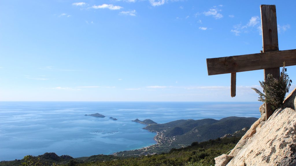
Turn left here, climbing up the slab of rock and leaving the main path. Once off the main path, head diagonally from the main path, across the rocky slabbed area then pick up the path the other side. The path snakes between the rocky outcrops, which you climb (a bit of a scramble in places) then pick up paths the other side. The path is relatively easy to follow, steep in places, always a mix of rocks and dirt paths. The distance cross country is approx 750m. After a sharp final dirt climb up a gullied path, you will arrive at the main path at an information panel on Crêtes Hautes. Turn right, walk 250m, you come to a sign TABLE D’ORIENTATION on the left that marks the short 50m trail through the maquis to the summit and the orientation table. You will soon see its distinct wooden cross and this massive metal structure that has been placed above, much to the locals dismay !


- Summit (to Central Solaire) 1h30/ 5km
From the summit area (a great place for a picnic and some photos), retrace your steps back to the main path, this time turn left and continue along the well waymarked path, through the boulders on this ridge, dropping down to the junction at a stone bergerie FINOSA which you will see after 1km. The small stone hut has been recently renovated, there is a great view over the Golfe d’Ajaccio to ISOLELLA.
Turn right at the bergerie, taking the path that drops downhill for 750m, the sea is on your left and the path is pretty open. The path forks, and you turn right. There is a signpost marking this junction, SITE DE LA PARATA for the direction you are heading.
Turn right, after another 750m you should pass the cross country path on your right, then follow the trail for 2.5kms back to the the car parking area.


