A seemingly little known coastal walk to the south of the village of TIZZANO. The Conservatoire du littorale holds a lot of this headland but the path is unwaymarked, as it seems there are little pockets of “private property”. It is a relatively easy stroll with no real climbs but the path is really messy and hidden in places, as the paths are unkept and little more than access routes for hunters.
To access the walk you need to drive towards TIZZANO, but 500m before the village take the road on the left that is signposted CAMPING L’AVENA. After just 1km the road becomes a rutted steep uphill dirt track so we parked, out of the way, on the side of the road and walked from there.
The coastal path is amazingly wild, much more so than the Campomoro to Tizzano section, but the access is poor, with frequent overgrown sections where the maquis has started to take back control. In season the beach at Tralicetu can be relatively busy, despite having poor access along another dirt track. We love it for the wild beaches and no one around… well almost !
13.5km, 4h00, +/- 200m, some cairns but not well marked and pretty overgrown.
- Col de Zivia (to coast at Paratella) 2km / 0h45
From the CAMPING L’AVENA entrance head uphill and continue as the road becomes a dirt track. After 400m on this track you reach a destinctive pass, and a junction of tracks at COL DE ZIVIA. You see dirt tracks leading in all directions, and on the col facing the sea, you need to take the wide track on your right that continues slightly uphill along the ridge towards some elusive villas. Continue along the track, and after 900m it passes to the left of the last villa and narrows to quad bike size. The track is easy to follow through high maquis, continue the gentle descent for the next 400m, to the point where the track doubles back on itself to your left. You continue straight ahead in the direction of the coast, along an ever narrowing path, dropping through high maquis. The first 200m is ok, but soon the path drops deeper into the maquis and becomes closed in for around 400m, once out of this you see the coast, and the worst is behind you. (NB. There should be a scrambly start to the walk from the beach at TIZZANO, but that is for another day!)

- Coastal path at Paratella (to Capu di Ziviu) 1.5km / 0h30
On arriving at this open area, to your right you see TIZZANO. Take the path left as it crosses this open coastal area covered in “griffes de sorcieres”. The path follows the coast, in low maquis, you pass rocks sculptured by the wind and rocky pass creeks. The path is relatively easy to follow, you can see the lighthouse and tower at SENETOSA across the water. As you move along the coast the path passes through more and more sculptured rocks, some pretty volcanic looking, before arriving at the remote pebbly cove at CAPU DI ZIVIU, with its impromtu cross and handcrafted beacon on the pebbles made from various flotsum and jetsum that has been washed up here.
- Capu di Ziviu (to Cala di Brijja) 1.5km / 0h30
Move away from the rocks of the coast and contourn the next inlet across a flat open area. After 10 minutes the maquis becomes denser and the path a little harder to follow, so care is required for the next 10 minutes to not become lost in the undergrowth, which never lasts for long. The path runs roughly parallel to the coast, contourning the occasional boulder, crossing grassy areas then dipping into small patches of higher vegetation. As you approach CALA DI BRIJJA, you are walking nearer the sea. You will see maritime pines, and the sea view opens out again. After a broken wooden cabin, head away from the coast along a path that leads to a turning circle at the start of a track.


- Cala di Brijja (to Plage de Tralicetu) 2.5km / 0h45
This is the easy part as you head along the track, ignore the paths off to your right towards the CALA DI BRIJJA, and at a Y junction as the rutted track starts climbing, approx 400m from the start (NB this is the return route to the COL DE ZIVIU), turn sharp right towards the sea along the track. This 4×4 track leads directly to the beach at TRALICETU, when level with the beach, you can cut the corner by crossing through some boulders into an open field, then dropping down behind the beach.
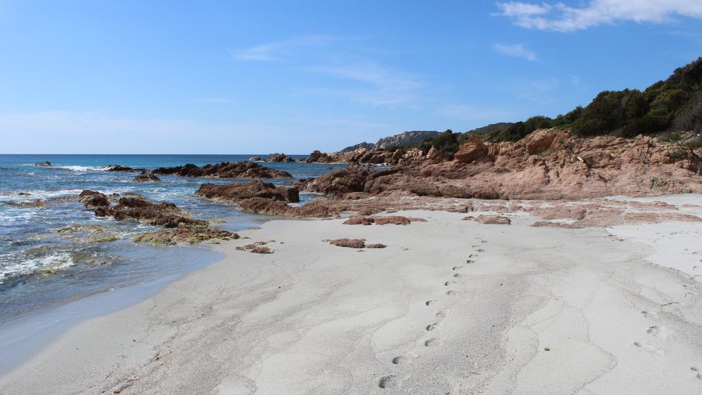
- Plage de Tralicetu (to Cala Barbaria) 1.5km /0h30
Cross the beach (and the stream if early in the season) and walk to the far side, take the sandy track through the dunes to discover the beach at CALA BARBARIA or the PLAGE D’ARGENT with its silver white sand. This is a great spot for a picnic !
EXTENSION – From here you can carry on towards PUNTA DI MURTOLI. Climb onto the rocks at the far end of the beach and follow the path that hugs the coast more or less for approx 20 minutes. You reach a large rocky area at the headland, the path heads inland here soon passing between rocks and a huge boulder and the path narrows almost loses itself soon after cutting through the maquis in little more than a hunter’s path. After another 5 minutes you fall out of the maquis suddenly as you arrive at a small beach at PUNTA DI MURTOLI at the edge of the select private estate.
The coastal path is in contention across the 5* Domaine de MURTOLI, initially it travels left along the track from the rocky cove, leading around 300m inland across a hunting estate – not ideal – to avoid the large and expensive bergeries favoured by the French elite – but there are some cairns that have been placed around the headland and closer to the coast, try it only out of season and to be honest if you dare. The tracks are really badly signposted and that alone shows that someone really doesn’t appreciate your presence. We found the return easier to follow from the beach, take the path up the wooden steps and past the purple restaurant signposted PLAGE D’ARGENT, the path heads along behind the coast to the larger stone houses, then crosses a track again signposted, and follows the barbed wire perimetre fence of one of the domaines more select properties. Again you cross hunting reserves and then reach the track to the back of the beach at MURTOLI.
Retrace your steps to CALA BARBARIA (Plage d’Argent).
- Cala Barbaria (to Col de Ziviu) 4.5km / 1h00
Retrace your steps to return to the PLAGE DE TRALICETU. Cross the beach and climb to the track that heads off left around the coast. At the junction you passed earlier, take the rutted climbing track to the COL DE ZIVIU.


