This is a once in a lifetime walk to see the summit of the wonderful CAPO D’ORTU 1293m high above PORTO, the views are really amazing, worth the effort but don’t whatever you do underestimate this one !
A real scramble up rocks and couloirs even on the “easy” route. The terrain requires all your attention and be well prepared, you’ll need lots of water, there is no shade, so set out early !

To start the walk, park your car at the Stade de Piana, on the right heading North on the D81, on the road out of PIANA, just before the road narrows into the CALANCHES DE PIANA.
13km / 8h30 / +/-850m.
Food supplies: PIANA / PORTO Please Note: Take more than plenty of water with you, this one is a long old slog in the heat.
- Stade de Piana (Chataignerie de Palani) 1h00 / 2km
From the parking area, walk towards the small football pitch. Cross the football pitch (stade) diagonally and cross the small wooden bridge. We turned left along the YELLOW waymarked path signposted LES ROCHES BLEUES, ROCHER DU LION, RUINES DE DISPENSA, ANCIEN CHEMIN de PIANA à OTA.
Having turned left after the little wooden bridge, the trail makes its way uphill through the maquis. The path opens out and you reach a pile of stones and signposts for the first intersection – ahead you see a stone balcony path that leads to the Sta Maria Oratoire on the road through the Calanche – this is the ANC CHEMIN MULETIER that linked PIANA with OTA which we describe elsewhere – but at the multitude of signs turn right, in the direction of CAPU DI U VITTELLU, ROCHER DU LION, RUINES DE DISPENSA, CAPU D’ORTU, ROCHES BLEUES, BOCCA DI PIAZZA waymarks are still YELLOW.
Walk uphill along the stony trail that goes into small copses then out in the open again for about 1km, you will come to another stone cairn and signpost. The left path goes drops through the trees in zigzags down to the road that leads through the CALANCHE (the path coming out opposite the ROCHES BLEUES café). Instead, take the right fork, in the direction of FNE D’OLIVIA BONA, DISPENSA, CAPU D’ORTU. You leave behind pines for the moment and walk under chestnut trees. After 250m you come to another intersection, there is a helicopter landing area, and a sign for the CHATAGNERIE DE PALANI.


- Chataignerie de Palani (to Bocca di Piazza – low route) 1h15 / 2.5km
After a look at the view over the Golfe de Porto, keep ahead across the open area with the views to your left. Signposted FNE D’OLIVIA BONA RNES DE DISPENSA BOCCA PIAZZA. After barely 100m the path climbs gently straight ahead leaving the path for the FNE and RNES behind as it drops slightly to the left.
Continue on the balcony path through the trees – it is soft underfoot and climbs gently. Through the forest, you will have glimpses down to the sea on your left, all the way towards the rocky outcrop marked PUNTA DI A PIANETTA on the map. The view suddenly opens up inland over a plateau of sculptured Tafoni rocks – you see the PAGLIA ORBA. Here the path takes a sharp right gently uphill through light woodland. The path soon opens up again to a rock slab landscape, keep an eye on the YELLOW waymarks, crossing this area before heading into dense woodland, and coming out by a rock face that it follows before arriving at the BOCCA DI PIAZZA where you see a signpost.
- Bocca Piazza (to junction to Capo D’Ortu) 0h10/0.5km
From here turn left for the CAPO D’ORTU, the path leads down through the trees, for around 10 mins until a path signposted with an old sign CAPO D’ORTU h50 leads off to the left climbing steeply over a rocky slabbed area with occasional cairns.
- Junction (to Capo D’Ortu summit) 2h00 /2km
Turn left uphill here, you need to take care in all weathers – after wet or cold weather the slabs are slippery, in the heat, you are in an oven, in a storm, you’ll be dead, in fog, completely lost. The next section is long, very long, you need to know the weather is with you, and be in good shape, the weather on this summit can change quickly so if it is looking doubtful, turn back before it becomes a problem.
The initial path continues climbing, zig-zagging up through the maquis and following the cairns over this rocky terrain. You cross over the first small ridge between the rocks, then drop down through higher maquis, onto an easier path, passing a red rock wind sculptured ridge, towards another rock scattered plateau (on your left) before the climb begins through the trees to the CAPO D’ORTU. The path here is easy underfoot, make the most of it and maybe take a short break in the shade before the next section.
It states ” h50″ minutes ascension for the CAPO D’ORTU from the sign, DON’T BELIEVE IT. From the rock scattered plateau, the path heads up initially through pines on a rocky path, then after around 5mins, the path then becomes a steeper slabbed rock passage until it takes a distinct left at a viewpoint under trees. Look behind you as the views of the Golfe de Porto open up. From here it gets interesting. Looking uphill to your left, you see the path, it again crosses an even trickier slabbed couloir, it is very obvious. The section is tricky, but it only lasts for approx 10m or so, you’ll need your hands for a bit, and take your time. After this couloir, the walk then becomes easier again over a rocky plateau, with broom and rosemary scattered. The views are amazing but always keep an eye on the cairns and keep the steady uphill climb.
As you reach the variant route (dotted on the map), near a lonesome pine, floating in a void between the rocky summits, the climb starts its challenging push uphill over rocky boulders, zig zagging up the mountain. Your knees will feel it. Keep an eye on the cairns (there are lots) and try to not stray, you aren’t too far now. Just below the summit, which you cannot see until nearly upon it, the path takes a distinct right up into a narrow rocky gully (straight ahead is another void). From the rocky gully, the path again turns uphill left along another gully (keep well aware of your surroundings, cairns). Clamber over a last rock, keep ahead and you are finally standing on a plateau below the final summit push.
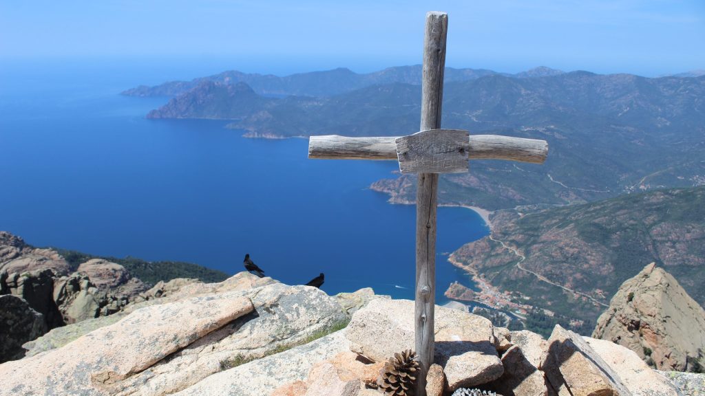
The last bit involves care, from the large rock, the path zig-zags up to the rear of the summit then over rocky slabs to the cross. You did it, now enjoy the views (sheer drop to Porto) before the descent.
- Capo d’Ortu summit (to junction for Stade de Piana) 1h30 / 2km
Retrace your steps back to the junction and turn right to take the path back home.
- Junction for Stade de Piana (to Stade de Piana) 1h30 / 4km
Just 100m before the BOCCA DI PIAZZA you will see a (fallen) signpost CAPO D’ORTU, FOCE D’ORTU etc. Turn left here into the pine forest signposted PIANA. The path is initially gentle underfoot with a carpet of pine needles, before it becomes much more stoney underfoot as it zig zags downhill, following a stream (there can be a lot of water on the path after rain). The path was waymarked but the waymarks are scarce.
Halfway down the waymarks become purple as you reach the lower slopes, and you will see signs showing you the flora of the ARBORETUM path. You see a sign that incicates the ARBORETUM loop to your left.
Keep following the purple waymarks along the valley. You arrive at the bridge by the STADE DE PIANA. Retrace your steps to your car or back to your hotel.


